


[08:54 Wed,11.January 2017 by Thomas Richter] |
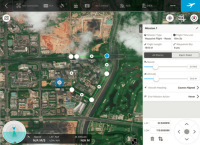
DJI has the App GS (Ground Station) Pro fuers iPad released, plan with the pilots on a map routes can, which is then executed on autopilot from the UAV - including photo shoot at predetermined locations. Per virtual fence (Virtual Fence) may also have a flight zone (including the maximum flying height) are determined, which may not leave the drone. The flight points are easily marked and stored on the card - your fingertips the flight is then started. The captured images can be imported via software for creating 3D maps of the landscape. It can also be defined POIs - like buildings - which are then automatically flew around and photographed from the UAV to create 3D models. PIC 1: flight planning is Meant by DJI Ground Station Pro https: // itunes Bild zur Newsmeldung:
deutsche Version dieser Seite: Kostenlose iPad App DJI Ground Station Pro: Kamera-Flug Planer und Autopilot |
|
|